
Advanced Hydrologic Prediction Service (AHPS) is a new and essential component of our Climate, Water, and Weather Services. AHPS is a web-based suite of accurate and information-rich forecast products. They display the magnitude and uncertainty of occurrence of floods or droughts, from hours to days and months, in advance. These graphical products are useful information and planning tools for many economic and emergency managers. These new products will enable government agencies, private institutions, and individuals to make more informed decisions about risk based policies and actions to mitigate the dangers posed by floods and droughts.
The majority of the observed water level data displayed on the AHPS web pages originates from the United States Geological Survey's (USGS) National Streamflow Information Program which maintains a national network of streamgages. In addition, real-time water level information is collected from other federal, state, and local streamgage networks.
Tags
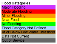
Map Legend
Map Type
Keyhole Markup Language (Google Earth KML)
Map Source
https://water.weather.gov/ahps/worldfiles/ahps_national_obs.kmz
Attribution
NOAA National Weather Service (NWS) Advanced Hydrologic Prediction Service (AHPS), River Observations.Jim Lee • Creator of ClimateViewer Maps

I am forever a Boy Scout, lifetime artist, nocturnal programmer, music is my life, love is my religion, and I am the luckiest husband and father on Earth. I speak for the trees. I have a passion for mapping, magnets, and mysteries. Feel free to contact me: jim@climateviewer.com