
SMUD Cloud Seeding Bidding
California Bid Network: Cloud Seeding and Forecasting Services - BackupBid Date & Time: 08/30/17 5:00 PM - Prebid: 08/14/17 11:00 AM
Solicitation Title: Cloud Seeding and Forecasting Services
Owner Solic Number: 170175.AM
Status: bidding
Report: 7955784
Country : United States
State: CA
County: Sacramento
Location: Sacramento
Est. Low Value: $900,000
Est. High Value: $900,000
Scope: An on-call basis during autumn, winter, and spring, commencing in 2017. The work shall include releasing silver iodide into the atmosphere from aircraft-based or ground-based units during appropriate storms. Notes: PRE PROPOSAL CONFERENCE Monday August 14, 2017 11:00 A.M.
Buyer: Sacramento Municipal Utility District, Supply Chain Services Office
Address: 4401 Bradshaw Road
City: Sacramento
State: CA
Zip/Postal Code: 95826
TEL: 916-732-5600
FAX: 916-732-5601
Website: http://www.bids.smud.org
Contact: Andrew McDermott
Contact Title: Procurement Specialist
TEL: 916-732-5862
SMUD Weather Modification Activities 2004 - 2012 (reported to NOAA)
SMUD Annual Cloud Seeding Report 2015
California cloud seeding projects winter 2004-2005

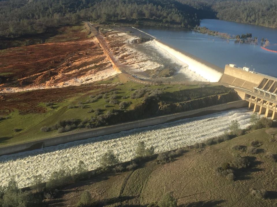
Lake Oroville Dam Failure
Oroville Dam is an earthfill embankment dam on the Feather River east of the city of Oroville, California, in the Sierra Nevada foothills east of the Sacramento Valley. At 770 feet (235 m) high, it is the tallest dam in the U.S. and serves mainly for water supply, hydroelectricity generation and flood control. The dam impounds Lake Oroville, the second largest man-made lake in the state of California, capable of storing more than 3.5 million acre-feet (4.4 km3).
In February 2017, the main and emergency spillways failed, leading to the evacuation of 188,000 people living near the dam. After deterioration of the main spillway largely stabilized[12] and the water level of the dam’s reservoir dropped below the top of the emergency spillway, the evacuation order was lifted. - Wikipedia

Tags
Map Type
GeoJSON
Map Source
More Info
https://weathermodificationhistory.com/
Attribution
Jim Lee, ClimateViewer NewsMap: Sacramento, California Cloud Seeding Near Failing Oroville Dam by Jim Lee is licensed under a Creative Commons Attribution-NonCommercial-ShareAlike 4.0 International License. Based on a work at climateviewer.org/. Permissions beyond the scope of this license may be available at climateviewer.com/terms.
 You are free to:
- Share — copy and redistribute the material in any medium or format
- Adapt — remix, transform, and build upon the material
- Attribution — You must give appropriate credit, provide a link to the license, and indicate if changes were made. You may do so in any reasonable manner, but not in any way that suggests the licensor endorses you or your use.
- NonCommercial — You may not use the material for commercial purposes.
- ShareAlike — If you remix, transform, or build upon the material, you must distribute your contributions under the same license as the original.
Sharing is Caring
Jim Lee • Creator of ClimateViewer Maps

I am forever a Boy Scout, lifetime artist, nocturnal programmer, music is my life, love is my religion, and I am the luckiest husband and father on Earth. I speak for the trees. I have a passion for mapping, magnets, and mysteries. Feel free to contact me: jim@climateviewer.com


Leave Us A Comment